
Need help?
support@quayis.com
- Condenser Microphones
- Network Antennas
- Juicers
- Car Video
- Choppers
- Bowls
- Appliances
- Digital SLR Cameras
- Movies & TV Shows
- Tablet Keyboards
- Electric Citrus Juicers
- Speakers
- Home Decor
- Pressure Cookers
- Ramadan Deals
- External Hard Drives
- Fitness & Outdoors
- Hair Straightening Brushes
- Irons
- Hair Dryers & Accessories
- Projectors
- Laser Printers
- sunglass
- Electronics & Mobiles
- Home Audio
- Power Banks
- Ovens & Toasters
- Dash Cameras
- Stands
- Woks & Stir-fry Pans
- Camera
- Consoles
- Musical Instruments
- Chargers
- Coffee Makers
- Office Electronics
- Lighting
- Dinnerware Sets
- Deals
- Instant Cameras
- Sports & Recreation Technology
- Handheld Vacuums
- Microphone & Headsets
- Hair Dryers
- Kitchen & Dining
- Microphone Accessories
- GAME ACCESSORIES
- Camera & Photo
- Video
- Headphones & Earphones
- Otg Ovens
- Surveillance Cameras
- Cooktops
- Cookware Sets
- Fragrances
- Television & Video
- Mobiles & Accessories
- Wall Chargers
- Drip Coffee Machines
- Telephones & Accessories
- LED Lighting
- Food Processors
- New Arrivals
- Mirrorless Cameras
- Gps Units
- Office Supplies
- Espresso Machines
- Beard & Mustache Care
- Glassware & Drinkware
- Microphone Stand
- ELECTRONICS
- Lenses
- Drone Cameras & Accessories
- Smartphones
- Specialty Appliances
- Television Accessories
- Power & Hand Tools
- Dome Cameras
- Laptop
- Portable Audio & Video
- Motion Sensing
- Fitness Trackers & Accessories
- Pianos
- Video Converters
- Centrifugal Juicers
- Kitchen Utensils & Gadgets
- Voice Recorders
- Monitors & Accessories
- Mobile Phones
- Tripods & Monopods
- Electric Shavers
- Hair Straighteners
- Cup & Saucer Sets
- Desktops
- Digital Camera Lenses
- Drone Cameras
- Tablets & Accessories
- Sandwich Makers & Panini Presses
- Projector Accessories
- Power Tools
- Bullet Cameras
- Luggage
- Microphones
- Action Cameras & Accessories
- Fitness Trackers
- Keyboards & Synthesizers
- Electric Kettles
- Steam Mops
- Cooking Timers
- Garment Steamer
- Monitors
- Feature Phones
- Hair Curling Irons
- Televisions
- Electric Cookers
- Memory Cards
- All in One PCs
- Accessories
- Accessories & Supplies
- Tablets
- Personal Care
- Projection Screens
- Hot Air Guns and Glue Guns
- Health & Nutrition
- Mobile
- Karaoke Microphones
- Sports & Action Cameras
- Outdoor Recreation
- Blenders
- Flash Accessories
- Stand Mixers
- Printers
- Toster
- Games
- Smartwatches & Accessories
- Upright Vacuums
- Soundbar Speakers
- Rice Cookers
- Dinnerware & Serveware
- Lighting & Studio
- Accessory Bundles
- Bags & Cases
- Home & Kitchen
- Shaving & Hair Removal
- Chargers & Cables
- Mixers & Attachments
- Health Care
- Pets
- Wearables
- Batteries & Chargers
- Camping & Hiking
- Hand Blenders
- Styling Products
- Furniture
- Inkjet Printers
- Watches
- Tools & Home Improvement
- Smartwatches
- Laptops
- Console Accessories
- Lighting & Ceiling Fans
- Plates
- Photography Lights
- Digital Cameras
- Camera Cases
- Kitchen & Home Appliances
- Men
- Safety & Security
- Mixer Grinder
- First Aid
- Stationary
- VR Headsets
- Camera Supports & Stabilizers
- Routers
- Portable Bluetooth Speakers
- Smoothing
- Game & Recreation Room Furniture
- Electric Pressure Cooker
- GPS & Navigation
- Electrical
- Mobile Phone Adapters
- Convertible 2 In 1
- Automotive
- Emergency Lights
- Dessert Plates
- Microphones & Headsets
- Point & Shoot Digital Cameras
- Mirrorless Camera Lenses
- Vacuums & Floor Care
- Trimmers & Clippers
- Flashlights
- Canister Vacuums
- Hot & Cold Therapy
- Toys
- Gaming Controllers & Joysticks
- Gimbals & Stabilizers
- Beauty & Fragrance
- Solo Microwave Ovens
- Shaving Kits & Sets
- Video Game Chairs
- All-In-One Printers
- camera lence
- Household Batteries
- Cases & Covers
- Notebooks
- Car & Vehicle Electronics
- Countertop Blenders
- Cookware
- Darkroom Supplies
- Video Games
- Lens Accessories
- Robotic Vacuums
- Fryers
- Game Cases
- Car Care
- Heating Pads
- Television
- Computers & Accessories
- Home
- Hair Care
- Large Appliances
- Hair & Scalp Treatments
- Power Drills
- Dinner Plates
- camera lens
- Camcorders
- Networking Products
- Small Appliances
- Car Electronics
- Lights & Lanterns
- Frying pans
- Film Processing Equipment
- Cameras
- Music
- Tablet Accessories
- Air Fryers
- Car Audio
- Hair Rollers
- Pressure Cookers & Accessories
- Sports & Outdoor
- Data Storage
- Sports
- Styling Tools
- Irons & Steamers
- Curls & Straightening Treatment
- Pressure Washers
- Film
- Camera Accessories


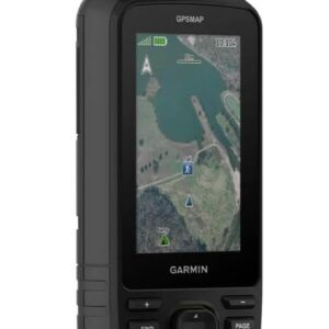
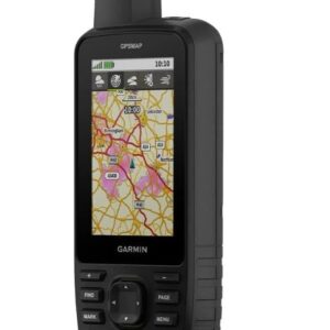
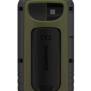
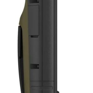
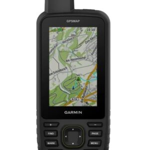
GARMIN GPSMAP 67
- 100% Authentic
د.إ 2,039.00
Shipping calculated at checkout.
Free Shipping Above 500 AED
7 in stock
Have any Questions?
Feel free to Get in touch
The Garmin GPSMAP 67 is a premium handheld GPS navigator designed for explorers, hikers, climbers, and outdoor professionals who demand accuracy, durability, and long-lasting performance in remote environments. Built to withstand the elements, it meets military-grade standards for thermal, shock, and water resistance (MIL-STD-810 and IPX7), making it a reliable tool in harsh terrains and unpredictable conditions. The device features a sunlight-readable 3-inch color display with button controls that work even when wearing gloves, ensuring usability in all weather situations.
Equipped with multi-band GNSS technology, the GPSMAP 67 offers superior positioning accuracy by connecting to GPS, GLONASS, Galileo, QZSS, and BeiDou satellite systems simultaneously. Whether navigating dense forests, deep canyons, or mountainous trails, users can rely on fast and precise location tracking. It comes preloaded with TopoActive maps and supports satellite imagery downloads, allowing users to plan and follow routes with detailed, real-world visuals. The inclusion of a barometric altimeter, 3-axis compass, and TracBack routing further enhances its navigational capabilities.
One of its standout features is the extended battery life — up to 180 hours in standard GPS mode and an impressive 840 hours in expedition mode, supported by a built-in lithium battery and convenient USB-C charging. This makes the GPSMAP 67 an excellent choice for long trips and backcountry expeditions where power sources are limited. Whether used for navigation, geocaching, or route planning, the GPSMAP 67 delivers dependable performance, advanced features, and the confidence needed to venture further off the grid.
| Specification | Details |
|---|---|
| Model Number | Garmin GPSMAP 67 |
| Display Size | 3.0″ (76 mm) diagonal |
| Display Type | Sunlight-readable color TFT |
| Display Resolution | 240 × 400 pixels |
| Battery Type | Built-in rechargeable lithium-ion |
| Battery Life | Up to 180 hrs (GPS), 840 hrs (Expedition) |
| Water Rating | IPX7 (Waterproof) |
| Built-in Memory | 16 GB |
| Memory Expansion | microSD™ card slot |
| Satellite Systems | GPS, GLONASS, Galileo, QZSS, BeiDou |
| Sensors | Barometric altimeter, 3-axis compass |
| Connectivity | USB-C, Bluetooth®, ANT+®, Wi‑Fi® |
| Preloaded Maps | TopoActive |
| Waypoints Capacity | 10,000 |
| Routes | 250 |
| Track Log | 20,000 points; 250 saved tracks |
| Dimensions (L × W × H) | 16.3 × 6.2 × 3.5 cm |
| Weight | 230 g |
7 in stock
You may add any content here from XStore Control Panel->Sales booster->Request a quote->Ask a question notification
At sem a enim eu vulputate nullam convallis Iaculis vitae odio faucibus adipiscing urna.
Reviews
There are no reviews yet.